| Monitoring of groundwaters in Hungary |  |
Quantity monitoring
The most important information are originating from the National Hydrological Basic Network operated by the District Water Authorities (DWAs). The collected data are forwarded to the Central Hydrological Data Archives annually.
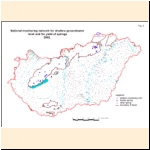
The Near-Surface Groundwater Level Monitoring Basic Network The approximately 70 years old near-surface groundwater-level monitoring basic network is providing most of the information about the upper zone of the basin-type areas (Figure 3). This network - levels recorded partly electronically partly manually (once or twice a week) - consists of 1642 wells at present.
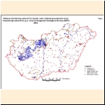
The Deep Groundwater Level Monitoring Basic Network The basic network, observing the levels of confined deep groundwaters in the basin-type areas, consists of 377 wells (Figure 4.). The levels are recorded at least monthly manually or registered automatically by the water authorities.
The Karst-Water Level Monitoring Basic Network The karst-water level monitoring basic network consists of 247 observation wells (Figure 4.), and further 3 wells are monitoring other fissured aquifers. The levels are recorded at least monthly manually or registered automatically.
The Groundwater Level Monitoring Network of MÁFI The above listed networks are supplemented by the 163 wells of the water level monitoring network of the Geological Institute of Hungary (MÁFI). These wells are presented also in Figure 4. MÁFI earlier measured the depth of shallow groundwater in a large number of exploratory drillings and dug wells in an expedition-like manner as well.
Basic Monitoring Network of Springs In the framework of the basic monitoring network of springs the DWAs are recording the yield of 52 springs at least monthly. Detailed pilot studies are being performed in the surroundings of Jósvafő located in the North-Borsod Karst Region. More than 4000 springs are registered in the National Cadastre of Springs.
Operational measurements The water supply companies are recording monthly the discharges and levels of the springs and operation wells used/operated by them. They send the data to the DWAs, which are forwarding them to the Central Hydrological Data Archives annually (4830 objects). In addition, on each spring and well, producing more than 500 m 3 per year, the user has to provide the production data to the DWAs, which are forwarding them (altogether 31700 objects) to the Central Hydrological Data Archives annually too.
Data acquired in the course of well-construction Monitoring is fairly supplemented by the water levels recorded in the course of the construction of approximately 75 000 wells.
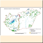
Vulnerable perspective and actual sources of supply The state-funded diagnostics of the vulnerable perspective and developed sources of water supply is running since 1993 (Figure 7). As investments of the district water authorities various contractors will execute a huge number of explorations in 78 perspective and 626 developed abstraction areas. Readiness of the operations scheduled up to 2009 is time-proportional so far. Up to now - considering the wells also of some earlier local monitoring networks – 2870 monitoring wells have been accomplished, however mainly for water quality monitoring.
|