| Guide - Groundwaters in Hungary |  |
GROUNDWATERS IN HUNGARY
Types of groundwater
A great part of Hungary in the centre of the Carpathian Basin is of flat and hilly character without significant mountains. In this basin-type area marine and fluvial deposits, sometimes as thick as several kms, cover the older rocks. The marine deposits situated at larger depth are mainly clays and clayey marts without the possibility of abstracting any water from them. As the Pannonian Sea turned into an inland lake, the rivers flowing into it deposited coarser sediments of a depth of sometimes 1 to 2 kms: the sequence of that time contains more sard and sandstone layers (Figure 1). In the Quaternary the fluvial sedimentation was already the characteristic process with silty, sandy and gravel deposits. Also the thickness of these complexes nears the 1 km in the Kisalf÷ld and in the southern region of the Great Hungarian Plain. At the border of the basin fans of the rivers are containing much gravel. Their thickness is only a few times ten meter, however in the Szigetk÷z region their thickness is several hundred meters. Some rivers are running in these formations and their water is in direct contact with the water contained by the gravel layers.
One group of the good aquifers is the coarser sandy and gravel layers of the clastic basin-deposits. At larger depth one can find sandstone instead of the loose sandy layers. These aquifers can be found in more than three quarter of the country's area assuring everywhere the chance for local drinking water production; while from greater depths (usually more than 500 m) the abstraction of thermal water is
probable. With wells bored into the shallow gravel aquifers along the riverbanks the filtered water of the river i.e. the bank-filtered water is being produced. The upper layers down to the depth of 10 to 20 m are of fine-grained formations with the possibility of local production of small discharges only. The majority of dug wells in the villages and countryside homesteads are producing water from such formations. However at some sites these formations have better productivity. Water located in the deposits near the ground surface is called shallow groundwater in this publication, the water in deeper clastic sediments is called deep (sometimes: confined) groundwater, when the temperature of the water is higher than 30 ░C it is called thermal deep groundwater, being a type of thermal waters.
Another main type of groundwater reservoirs is the group of karstic rocks that can be found in half of the hilly areas amounting one fifth of Hungary's territory. These calciferous marine sediments of the Mesozoic (limestones, dolomites) may conduct the water very well along faults, fractures and holes widened by the water of high carbonic acid content during the process of karstification. Precipitation infiltrates mainly directly and quickly into the outcropping karstic rocks, therefore the recharge of karstic waters is good. Karstic formations are covered by geological formations of low conductivity at many sites also in the hilly regions while at the margins of such territories the karstic reservoir may be covered with clastic sediments of large (sometimes several km) thickness, generally impermeable, lying directly above the karstic formations. In the karstic formations at the margins of mountains and in large depth below the ground surface in the basin-regions thermal waters can be found, part of which comes to the surface in the form of the well known thermalkarst springs (Hķviz, Budapest, Eger, etc.).
Beyond the main groundwater types set forth above (bank-filtered, shallow- deep groundwaters and the karstic waters) water can be exploited to a less extent also from other geological formations. Parts of the hilly regions are built up of non-karstic rocks (crystalline, volcanic or sedimentary formations of lower yield) from which smaller springs of local significance are coming out (Figure 1).

Figure 1
Water bearing formations in Hungary (without geothermal aquifers)
Subsurface flow systems, water level and pressure distribution
One can find water as old as the rocks which contain it only in a very small part of the formations introduced above, e.g. in the confined geological structures settled in large depth. In case of marine sediments these waters are of high salt content. Also hydrocarbons are accumulated in these closed geological structures. However in a large portion of subsurface reservoirs water is in permanent movement, it is being recharged from the ground surface, and moving toward the discharge areas it arrives again at the surface. The time of water exchange (traced with various isotope tests) vary on a very wide scale from a few hours to several hundred thousands of years. According to the radiocarbon tests the age of the water of drinking water quality stored in the sediments in the basin-type areas is in the order of magnitude of thousand years, while the age of thermal waters at larger depth may reach the one million year. In shallow groundwater contained by the coarser sediments near the surface and in the bank-filtered waters along the rivers the few days old rainwater and the water of the rivers are appearing together. Water originating from the rainfall of the last forty years can be detected through tritium tests. With all these one can come to conclusions on the intensity of the recharge. At the average precipitation between 500 and 700 mm/year prevailing in Hungary, infiltration is the highest in the karstic regions: 150 to 200 mm/year, in the basin-type areas of sandy topsoil it is 50 to 100 mm/year while it is only 5 to 10 mm/year or less in the case of finer loess-silty-clayey topsoil. It comes from the foregoing that the flow velocity of groundwater is very low: it is in the order of magnitude ranging from 0,1 to 10,0 m/year as an average, however in coarser debris and in karstic areas it is higher; in karstic fissures the flowing water travels several hundred meters per hour. In determining the age of karstic water the use of tracers is a widespread method: this means giving various paints and tracers to the water when disappearing in the sinkholes and observing their appearance at the springs.
Waters infiltrating in the highly positioned areas are flowing towards the discharge areas in the depressions. The subsurface flows of groundwater may be regional and local flow systems (Figure 2). In the case of fissured and karstic formations groundwater flowing below the ground surface comes again as springs out to the surface, In other mountainous areas beside the springs the infiltration into the riverbeds at discrete points is the more important, while in hilly regions groundwater is appearing mainly in the damp bottoms of the valleys. In flat regions mainly the areas of high groundwater level are representing the discharge areas where the water moving upwards is evaporating or is being evaporated by the vegetation (Figure 3).
The spatial distribution of groundwater levels or heads (in the case of confined aquifers) is in accordance with the flow pattern described above: levels are in higher position in the recharge areas than in the discharge areas. In the case of layered deposits in recharge areas with downward flow, groundwater levels are decreasing in the wells when proceeding towards larger depths, while in discharge areas of upward flow the opposite phenomenon can be observed. In wells reaching the aquifers covered with layers of low or no permeability water rises highly above the altitude of the tapped layer moreover in the depressions of discharge areas the level of water in the wells may rise even above the ground surface. With these so-called artesian wells water can be produced without pumping utilising its pressure only. Wells with water levels above the ground surface ("positive" wells) were widespread in the lowland areas of Hungary. In wells with water of higher temperature the level of water column is elevated also by the higher temperature and lower density of water and by the gases present in the water in dissolved form or separated as bubbles.

Figure 2
Regional groundwater flow-system in the Duna-Tisza region

Figure 3
Types of areas according to the geological and relief condotions
The groundwater household, the levels and heads are depending on the hydrometeorological conditions, on infiltration and recharge and on the production of water. In the 80s the high rate of water production coincided with the dry weather, the large withdrawal exceeded the reduced recharge for a long time, therefore a significant loss could be detected in the groundwater household: water resources stored below the ground surface decreased leading to the fall of water levels. The decrease of karstic water and deep groundwater levels does not represent an environmental problem in itself however it indicates overuse and may be allowed on the long run only if the process of decrease stops and a new equilibrium takes place. The decrease of. the yield of springs and that of the levels of shallow groundwater has more serious environmental constraints: the decrease may not be as large as to deteriorate the conditions of ecosystems.

Figure 4
Groundwater abstraction in the years 1981 to 1999
Exploitation of groundwaters and the impacts thereof
Mankind was familiar with groundwaters in the form of springs coming up to the ground surface and as water appearing in the dug wells of small depth. Furthermore, water entering the adits of the mines brought some problems about. Exploration of the water of deeper horizons with bored wells started in the 18 th century and this technology is already the most widespread method of water abstraction in Hungary. From the riverside gravel layers water is produced with so-called radial wells (consisting of a shaft of large diameter and a few radial, perforated, horizontal drain pipes conducting the water into the shaft), and with drains driven below the riverbed.
About 2,7 million m 3 water is produced from below the ground surface a day in Hungary at the present time. The distribution of this volume among the various types of groundwater is as it follows:
- near half of it comes from deep groundwater,
- about one third from bank-filtration water,
- about one sixth from karstic water,
- about one twentieth of it comes from shallow groundwater (illegal water withdrawals from shallow groundwater neglected).
The production from below the surface in the 80s was by 50 per cent higher than the present rate (Figure 4). The reason of this decrease can be found in the increase of the price of water stimulating the users to save water. The largest decrease can be observed in the abstraction of karstic water: the abstraction has fallen to one third of the volume abstracted in the 80s because of the decrease of the former large abstractions of mining industry in the early 90s and because of closing up the relevant mines. The reduction of abstraction in the Transdanubian Range was necessary from the point of view of water resources management as well: the rate of the abstracted karstic water was near twice as high as the recharge in the 80s (Figure 5) and the production from deep groundwaters nearly reached the rate of allowable long-time production limits. The overuse resulted in stopping of springs and in the large-scale fall of the level of karstic water in the karstic areas, in the decrease of deep groundwater heads and that of the levels of shallow groundwater in the basin-type regions.
- the largest decrease of levels could be experienced in the karstic reservoir of the Transdanubian Range (Figure 6) after the stoppage of several large karstic springs. The decrease exceeded the 30 m as an average and the 100 m at some sites. The withdrawals have decreased considerably since the beginning of the 90s mainly in connection of closing up the mines. Therefore and because of the higher precipitation regional rise of karstic water levels can be observed (Figure 6). It is more important that water levels are rising in the vicinity of the strongly endangered valuable thermal springs (Lake Hķviz and the Budapest thermalkarst system). The yield of the Hķviz Lake slowly increases (Figure 7). From the 60s several springs yielding a large volume of lukewarm and warm water stopped in the Transdanubian Range; their operation has started again at the late 90s or may be expected in the near future (Figure 8).
- since the 70s the lasting fall of the levels of deep groundwaters could be observed mainly as a result of water abstraction. In the layers yielding water of drinking water quality the level/head decrease of 5 to 10 m is experienced. In the vicinity of major water supply works and in the deeper thermal water reservoirs the decrease reached even the value of several times 10 m (>Figure 9). The results of the decrease of water abstraction in the early 90s became visible in the level variations: the decrease has been moderated and increase can be experienced at some places.
- the variations of levels of shallow groundwater are depending on precipitation: loss or surplus of infiltration is accumulating through years (Figure 10). The household of shallow groundwater is influenced also by the fact that the flow conditions has been changed due to the (limited) hydraulic connection and to the abstraction of deep groundwater set forth above. The downward movement of water has increased in the recharge areas while in the discharge areas the upward flow has been decreased or stopped. The drop of groundwater levels could be experienced on a nationwide scale in the 80s; at some places it was especially large. In some areas of the Duna (Danube)-Tisza Plateau the drop of shallow groundwater-level exceeded the value of 3 m (Figure 11). The reason was mainly the precipitation loss in the two decades before the last few years, however the impact of the abstraction from deep groundwaters can be detected as well. The rainy weather in the second half of the 90s moderated the drop of groundwater levels here; moreover some rise of levels can be detected at some places. According to the forecasts significant rise of the groundwater levels can be expected in the next decade if the rainy weather lasts for a long time.
Temperature of groundwaters, the geothermal situation
The geothermal gradient (indicating that how many ░C is the increment of temperature per depth-unit) is 5 o C/100 m being about one and a half times bigger than the worldwide average. The reason for this is that in the Pannonian basin including Hungary the earth-crust is thinner (as thick only as 24 to 26 km) than the worldwide average of 30 to 35 km. Moreover the basin is filled up with well insulating clayey and sandy sediments. The measured values of thermal flux (i.e. the heat-output coming from large depths) are high (90 mW/m 2 as an average) while the average is 60 mW/m 2 in the European continent. The mean temperature is about 10 ░C on the surface of the country.
In accordance with the geothermal gradient mentioned above the temperature of the rocks and that of the water contained by them is 60 ░C at the depth of 1 km and 110░C at the depth of 2 km. In the South- Transdanubian region and in the Great Hungarian Plain the geothermal gradient is higher than the countrywide average while it is lower in the Kisalf6ld region and in the hilly areas. Water moving upward in the thermal wells cools down along the casing therefore the temperature rarely exceeds the 100 o C on the surface. Steam occurrences of large depth are known only in a few, not sufficiently explored sites.

Figure 5
Variations in the water-household of the Transdanubian Range (DKH)
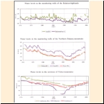
Figure 6
Karstic water levels in the Transdanubian Range

Figure 7
Yield regime of Lake HķvĒz, of the Budapest thermalkarst-system and the observed water levels in their environs 1951-1999

Figure 8
Variations in the yields of karst springs in the Transdanubian Range

Figure 9
Levels of shallow- and deep groundwater in the southern part of the Great Hungarian Plain
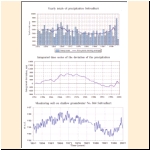
Figure 10
Comparison of the yearly total precipitation and the integrated values of their deviation from the average to the level-changes of shallow groundwater
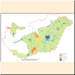
Figure 11
Deviation of the average level of shallow groundwater in the year 1999 from the average of the years 1956 to 1960
In Hungary the wells and springs yielding water warmer than 30 ░C are considered thermal wells/thermal springs. Thermal water can be accessible in about three quarter of the country's area (Figure 12). Some more detailed information can be found in the Guide published by MoE in the year 2001: "Thermal Water Resources in Hungary, their Utilisation and Protection"
The intensive drop of heads in the deep thermal water reservoirs of the basin-like regions caused by the production of thermal water (Figure 13) stopped or has got moderated in most of the sites since the late 80s. Although information on the rate of production are incomplete, the moderation of the drop may be attributed to the decrease of production even having only unsatisfactory data.
About 30 per cent of the wells producing thermal water is used for balneological purpose, more than one quarter is operated for water supply and almost half of them are used for geothermal energy production. On water management reasons the abstractions utilised only of geothermal energy would not be permissible without re-injection in the future: the cooled water should be re-injected into the geothermal aquifer.
Quality of groundwater
The quality of groundwater is determined mainly by the rock in which it is stored or where it is in movement. The original quality of water is highly influenced by the flow, by the travel time of water below the ground surface and temperature has a certain influence as well. The original quality can be changed also by the pollutions of human origin as well, mainly near the surface.
In the 500 m thick upper zone of the gravel- and sandy aquifers used for drinking water supply in the basin-areas one can find water of less than 1 g/l dissolved solid content. In the recharge areas the calcium-hydrogen carbonate (hard) type is the characteristic, which in the direction of the flow changes into the alkali-hydrogen carbonate (soft) type. In the central discharge areas of the basin-region (e.g. in the middle of the Plain) the water with upward movement is so soft that it can hardly be used as drinking water. At some places manganese and ammonium can be detected because of anaerobic processes. In a certain portion of deep groundwater the natural arsenic content causes problems in drinking water supply and the methane content brings about the danger of explosion. It comes from the foregoing that the natural quality of deep groundwater is not always in compliance with the requirements of drinking water supply. Even the deep groundwaters without contamination of human origin are demanding some treatment, their composition causes problems in the course of water treatment and distribution: secondary pollution is caused by the high ammonium and organic content.
Waters in the geothermal reservoirs below 500m are of alkali-hydrogen carbonate character. The total dissolved salt content is generally 1 to 3 g/l, however it can reach the value of 10 g/l. Waters of higher salt content are occurring in the deeper, confined zones of the reservoirs. In such position waters are characterised by higher chloride content and their composition is similar to the seawater. The gas content of thermal waters is very high at many places: 1 m 3 water transports several cubic meters of gas up to the ground surface. Beside the methane the carbon dioxide may be significant, the separation of which results in the deposition of dissolved lime in the pipes, causing problems in the operation. In the water of certain wells oil and phenol occurs as well.
Karstic waters are basically of calcium-magnesium-hydrocarbonate character because of the dissolution of carbonate rocks. The process of dissolution starts immediately after infiltration: water takes carbon dioxide from the soil and dissolves the carbonate rocks. The dissolved solid content of cool karstic waters is low, they are highly suitable for drinking water supply, however, they can be polluted more easily from the surface.
The dissolved solid content of lukewarm and warm karstic waters is low in the zones of more intensive flow: their total dissolved salt content does not reach the value of 1 g/l (e.g. Hķviz). At larger depth the carbon dioxide originating from the metamorphosis of sunken rocks, furthermore the mixing of cool and warm waters again makes these waters able for dissolution. This is how the caves of thermal origin have been developed in the vicinity of the thermal springs in operation (e.g. in Budapest). Because of the contact with the clay present in the carbonate rocks the chemical character of the water can be of alkali hydrogen-carbonate nature, from the decomposition of pyrite considerable amount of sulphate can originate and sulphur can occur also in the form of sulphide. In confined thermalkarst reservoirs located at larger depth the NaCl concentration may increase: in some cases it can reach the concentration of several times 10 g/l corresponding to the seawater (e.g. Rßbas÷mjķn). The greatest portion of gases occurring in thermal karstic water is carbon dioxide, which makes these waters aggressive.
The greatest portion of Hungary's groundwaters is suitable for drinking water supply; deep groundwaters after the proper water treatment technology, the other types with disinfection only. The public health limit values by components were provided earlier by a national standard (Standard MSz 450-1-1989). At the time being the Government Decree No. 201/2001 (X. 25.) Korm. on the quality requirements of drinking water and on the order of supervision contains the new limit values complying with the requirements of the European Union. These regulations are referring to tap waters. Annex 3 contains the new limit values together with the pollution limit values referring to the quality protection of groundwaters and geological media contained by the Joint Decree No. 10/2000. (VI.2.) K÷M-E▄M-FVM-KHVM of the competent ministers. In determining the latter the relevant regulations of the EU and the preservation of groundwater quality were the definitive aspects.
The special chemical composition, the quantity of dissolved salts and of the radioactive substances are making certain groundwater occurrences suitable for the utilisation as mineral and medicinal waters or as refreshment drinks after bottling or in the form of drinking- and bathing cure. Qualification of registered medicinal waters is possible only on the basis of medical tests verifying their medical effects i.e. the chemical composition of the waters in itself is not enough, each water abstraction should be qualified separately. The registration as qualified mineral water is possible in the case of waters protected and unpolluted by virtue of their origin when they are containing at least 1 g/l total mineral content or 0,5 to 1,0 g/l mineral content together with some biologically active substance in the concentration above a specified limit value (see Decree No. 74/1999. (XII.25.) of the Minister of Public Health).

Figure 12
Areas suitable for the exploration of thermal water in Hungary and the spatial distribution of geothermal wells

Figure 13
Water levels in the observation wells of the Geological Institute of Hungary
Waters of higher temperature are containing more dissolved substances in general, therefore a great part of the registered medicinal waters in Hungary are thermal waters (Figure 14). The curative effect of thermal waters comes from their high dissolved solid content (calcium-magnesium-, sodium-potassium-hydrogen carbonate, sulphate, chloride), however the biologically active substances of lower concentration have their role as well (e.g. sulphur, carbonic acid, radioactivity). A type of cool mineral- and medicinal waters is represented by the post volcanic occurrences of sour waters with high carbonic acid and iron content (Parßd, Balatonf³red, etc.); an other group is the bitter waters found in clays (Budapest, Nagyigmßnd, etc.).
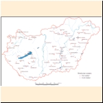
Figure 14
Settlements with registered medicinal water
Sensitivity of groundwater reservoirs against pollution
It comes from the review of water bearing and/or highly permeable geological formations in the foregoing that the shallow reservoirs of good recharge and high permeability are the most sensitive ones against the pollutions of surface origin. The pressure conditions of groundwater reservoirs have a certain role as well: in the areas of infiltration and recharge the contamination can move downwards together with the water; this can occur in the discharge areas of upward flow only locally. Pressure however can change because of the withdrawals and the contamination can move downwards in areas where the flow had an upward direction before. In karstic areas through the outcrops of carbonate rocks contamination can move without any obstacle down to the level of karstic water and even further down because of the strong mixing of water. In such areas also the lateral movement and the spread of contamination are fast. In basin areas basically the shallow formations are defining the spread of contamination: it is very fast in the gravel layers similarly to the karsts, slower in sandy layers and very low in the silty, clayey layers. In the latter cases also the adhesion of contamination on the surface of the fine grains may have a certain role in the slow spread of contamination.
A wide scale of pollution sources is endangering groundwater, however it must be emphasised that a certain part of the quality problems is connected to the natural properties of waters (e.g. the high iron manganese and ammonium concentration of deep groundwaters), but the high nitrate concentration hints to pollution of surface origin. (Figures 15) and 16 are showing the distribution of the above components in the various types of water related to the public health limit value, on the basis of the data provided by the Basic Quality Network of Groundwaters.
Nitrification is the most frequent contamination process, caused dominantly by municipalities without sewerage, and the use of manure and fertilizers in agriculture. The public health limit-concentration was 40 mg/l according to the Hungarian drinking water standard up to now and 50 mg/l from now on. It can be seen in (Figure 16)that the ratio of nitrate concentration above the limit value is significant only in the samples taken from shallow groundwater, the ratio -is 5 to 10 per cent in near-surface deep groundwater, while it is negligible in waters located deeper than 50 m.
Some pesticide residuals were detected in the water of near-surface aquifers, in the vicinity of industrial pollution sources a.o. heavy metal contaminations were observed.
The Hungarian water and environmental legislation in harmony with the directives of the EU well establishes the protection of groundwaters against pollution: it designates areas of various sensitivity grades on regional scale (Figure 17) based mainly on the extension of near-surface formations transmitting the pollution, and taking into consideration the position of the main aquifers used in drinking water supply. In these areas the necessary measures should be made taking into consideration the limit-concentrations of hazardous polluting substances depending on the spatial sensitivity (Government Decree No. 33/2000. (III/17.) Korm. on activities that affect the quality of groundwater).
Beside the general, regional protection the elevated safety level of the sources of drinking water supply and that of the mineral and medicinal waters should be ensured as well (Figure 18). This objective is served by the designation of protective blocks and protection areas in the various zones of which the activities endangering the quality of groundwaters should be limited to various extent (Government Decree No 123/1997. (VII.18.) Korm. on the protection of the actual and perspective sources and the engineering facilities of drinking water supply). The government launched a large-scale action programme relating to the vulnerable active and perspective sources of drinking water supply (such are the karstic, bank-filtered, shallow groundwater- and shallow confined water resources) in the framework of which these protective blocks and protection areas are being designated. The monitoring systems indicating the changes in water quality or in the hydraulic conditions influencing it are being developed in this process as well.

Figure 15
Distribution of Ammonium in the various types of water (data of the year 2000)
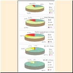
Figure 16
Distribution of Nitrate in the various types of water (data of the year 2000)

Figure 17
Sensitivity maps in accordance with Goverment Decree No. 33/2000 (III.17)

Figure 18
Operating and prospective vulnerable drinking water
|